
Angle Inlet, Minnesota: Visiting the Northernmost Point in the Lower 48 States
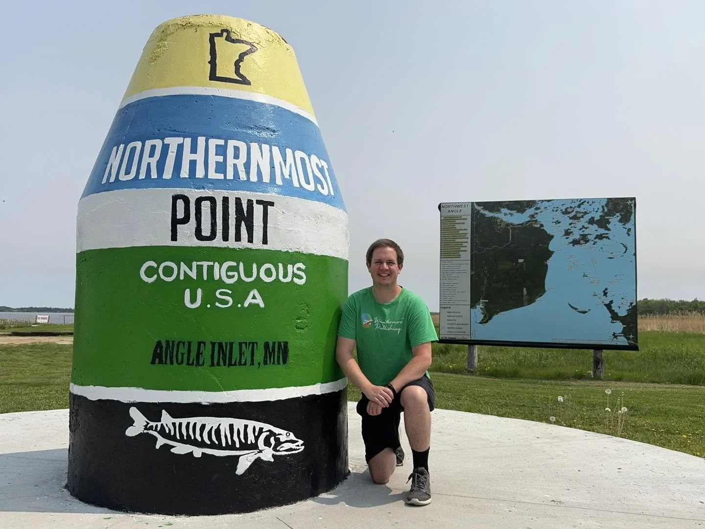
The Northernmost Point Contiguous U.S.A. marker mirrors the buoy at America’s Southernmost Point in Key West, Florida!

With a ZIP code of 56711, the Angle Inlet post office serves as the northernmost post office in the contiguous United States.

Serving one of the nation’s most isolated communities, Angle Inlet Elementary School is Minnesota’s last one-room schoolhouse.

You’ve re-entered the U.S.A. from Canada when you come across this “Northwest Angle” sign on Provincal Road 525!
Population: 54 (Unincorporated)
County: Lake of the Woods County
Few places in America are as geographically unique—or as challenging to reach—as Angle Inlet, Minnesota. Located within the Northwest Angle, this remote community is home to the Northernmost Point of the Contiguous United States, making it the only portion of the lower 48 states situated north of the 49th parallel. Surrounded by the waters of Lake of the Woods and accessible only by boat, ice road, or a drive through Canada, Angle Inlet is one of the nation's most fascinating geographic oddities. If you’re looking to learn more about the logistics of getting there, read on for exact instructions and “wander more” with me as we take one of America’s most underrated road trips!
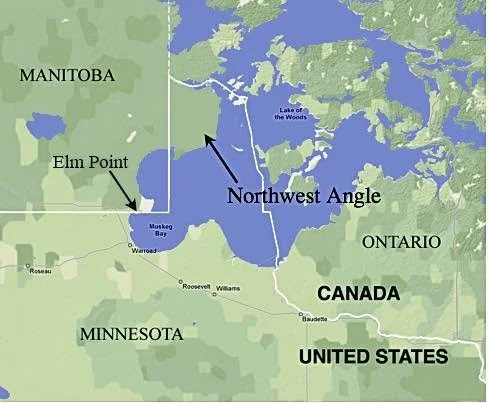
How a Mapping Error Created the Northwest Angle
The Northwest Angle exists because of a mistake made more than two centuries ago. When the 1783 Treaty of Paris established the border between the newly independent United States and British North America (modern-day Canada), negotiators believed the Mississippi River extended much farther north than it actually does. The treaty described the border as running from the "northwesternmost point" of Lake of the Woods toward the Mississippi.
Benjamin Franklin successfully convinced British negotiators to accept this boundary language, but later surveys revealed a problem: the Mississippi River was nowhere near Lake of the Woods. When surveyors established the 49th parallel as the international boundary in 1818, a small piece of American territory remained isolated north of the new border. The result was the creation of the Northwest Angle and its many islands—an American enclave physically separated from the rest of the contiguous United States.
Today, the Northwest Angle encompasses approximately 123 square miles of land and water.
You have to want to visit the Northwest Angle. It’s nearly impossible to just “stumble” across!
A Tiny Community at the Top of the Lower 48
Although its history stretches back centuries, the modern community remains remarkably small.
The area's European history dates to 1732, when French explorer Pierre Gaultier de Varennes, sieur de La Vérendrye, established Fort Saint Charles nearby. Today, however, the Northwest Angle is home to only about 54 permanent residents according to the 2020 U.S. Census.
Despite its tiny population, Angle Inlet boasts an impressive collection of superlatives. It is home to:
The northernmost post office in the contiguous United States
The northernmost golf course, Northwest Angle Country Club
The northernmost bar, Jerry's Restaurant & Lounge
The northernmost school, Angle Inlet Elementary School
The northernmost road in the lower 48 states
For a community with only a few dozen year-round residents, that's quite a list!
Visiting the Northernmost Point
Most visitors travel to the Northwest Angle for one reason: a photo at the famous "Northernmost Point" marker. The buoy-style monument, which reads "Northernmost Point: Contiguous U.S.A.", has become one of Minnesota's most unique roadside attractions.
Interestingly, the marker is not located at the actual northernmost point. Placing a monument in the surrounding swamp would have made it nearly inaccessible to visitors. Instead, a group of locals—including Joseph Laurin and Richard McKeever—worked together to establish the monument on the grounds of Young's Bay Resort, where travelers can easily reach it.
The attraction has become Minnesota's answer to the famous Southernmost Point buoy in Key West, Florida.
Resorts and Fishing in the Northwest Angle
While geography draws curious travelers, fishing remains the backbone of tourism in the area.
Several resorts cater to anglers and outdoor enthusiasts, including:
Prothero's Post Resort
Angle Outpost Resort
Young's Bay Resort
The surrounding waters of Lake of the Woods are renowned for world-class walleye, northern pike, and muskie fishing, drawing visitors from across the United States and Canada.
The Ice Highway of COVID-19
One of the most remarkable chapters in the Northwest Angle's recent history occurred during the COVID-19 pandemic. Because travel through Canada became restricted, residents and visitors suddenly faced significant challenges reaching the Angle.
A 37-mile ice road was constructed across frozen Lake of the Woods, connecting Springsteel Resort near Warroad directly to the Northwest Angle. For a fee ranging from approximately $145 to $250 per vehicle, travelers could access the community without crossing an international border.
The temporary highway became a lifeline for residents and a national news story, demonstrating the ingenuity required to live in one of America's most isolated communities.
Getting to Angle Inlet
Reaching the Northwest Angle is an adventure in itself! During much of the year, travelers drive through Manitoba, Canada, before re-entering the United States at the Angle.
I personally crossed at the Roseau-South Junction Border Crossing, but the most common route follows:
Minnesota Highway 313 to the Warroad-Sprague Border Crossing
Manitoba Highway 12
Provincial Road 308 (mostly gravel)
Provincial Road 525 (also mostly gravel)
Northwest Angle Border Crossing
Unlike most international crossings, the Northwest Angle crossing has no staffed border station.
Instead, travelers continue to a location known as Jim's Corner, where they use a video kiosk to check in with U.S. Customs and Border Protection. Upon leaving the Angle, travelers must notify Canadian authorities before re-entering Canada and later report again to U.S. Customs when returning to Minnesota. The unusual process has become one of the defining aspects of visiting the region. Just don’t forget your Passport…you’re still traveling between countries!
Specific instructions: From Warroad, follow Highway 313 into Manitoba, continue west on Highway 12 to Sprague, turn north on Provincial Road 308, east on Provincial Road 525, check in at Jim's Corner upon re-entering the United States, and continue to Angle Inlet via County Road 49 and Young's Bay Drive. Note that cell service is spotty, so printing off any maps or other necessary documents ahead of time would be wise!
Could the Northwest Angle Have Become Part of Canada?
The complexities of life at the Northwest Angle have occasionally sparked political debate. In 1997, then-Congressman Colin Peterson introduced legislation based on a mock proposal drafted by resident Gary Dietzler that would have allowed the Northwest Angle to leave the United States and join Canada. The proposal was largely driven by concerns over differing fishing regulations between the two countries and the logistical challenges of accessing the community.
His idea ultimately went nowhere and received strong opposition from the Red Lake Nation, which owns much of the surrounding land. However, the discussion did help bring attention to the region's challenges, and fishing regulations were eventually better synchronized between the United States and Canada.
A Journey Unlike Any Other
Angle Inlet is one of those rare places where the journey is just as memorable as the destination. Whether you're crossing multiple international borders, checking in with customs via an iPad in the middle of the woods, or standing at the northernmost point in the contiguous United States, a trip to the Northwest Angle offers an experience unlike anywhere else in America.
For wanderers seeking hidden destinations, unusual geography, and stories that few people know, Minnesota's best-kept secret is waiting for you at the top of the map!
The photographs accompanying this post document my journey to and from Angle Inlet in chronological order. Save this guide if you're planning a visit of your own. During my trip, I entered Canada via the Roseau–South Junction Border Crossing and returned through the Warroad–Sprague Border Crossing.
Learn more about Lake of the Woods County in Minnesota by picking up a visitor’s guide here. Explore Minnesota’s full state guide is available here.

Jerry’s Restaurant & Bar is located only yards away from the Northernmost Point marker; it’s America’s northernmost bar!

Underneath all that melty cheese is one of the best burgers you can get in the Angle. Cheese bites as a side are a must!

Jim’s Border Crossing Station is hard to miss. You’ll need to check in with border patrol when you enter and leave the Angle.

Making my phone call to Canada to let them know I’m on my way out! Spoiler alert…I was allowed back into the U.S.A. within minutes ;)
Enjoy learning about Minnesota’s communities? Follow Wandermore in Minnesota on Facebook for more small-town stories, local history, hidden gems, and travel inspiration from across the Land of 10,000 Lakes. We're on a mission to explore and document all 856 incorporated communities in Minnesota—one town at a time. Join thousands of fellow travelers and history enthusiasts as we wander more through Minnesota together!
If you'd like to dive even deeper into Minnesota’s towns and history, be sure to check out Wandermore in Minnesota,
our pictorial and historical travel guide featuring all 856 municipalities in the state. Whether you're planning your next road trip or simply enjoy discovering Minnesota’s hidden stories, it's the perfect companion for your journey.